
Available in printed paperback RRP £9.49 plus P&P £2.99. 3-5 working days.
From or from
Hint: To save time, copy this >> Historical Geology in Maps. Roberts.
and paste it in when you arrive at Amazon.
SPECIAL OFFER
Direct from us at Russet Publishing - rapid delivery
High definition electronic PDF version. 2 for the price of 1.
One for your PC/laptop and one for your tablet/smart phone.
Only £9.49 VAT-free. (No P&P. No printing or postal delay.)
Add to cart and set quantity to 1 on the cart page. We will send 2.
Maps of the Ancient Geology, Geography, Coastlines, and Climate of the British Isles and Ireland.
£9.49 Published by Russet Publishing. 2016. 153 US-letter-sized pages.
Supplied as a PDF book. No VAT, No postage, No packaging, No courier.
This is a different type of geology book in that it tells the geological story of the British Isles and Ireland by means of maps with accompanying descriptions. People find maps much easier to understand than just a lot of complicated text. Detailed maps of each major period allow you to picture what the British Isles was really like at any given time over the last 543 million years. That means from the Cambrian up to the present time.
However, the book actually starts with a set of maps that shows the world's tectonic plate movements over the last 750 million years. How did the continents develop and coalesce to the form the shapes that we recognise today? Where were the British Isles or North America,India, or Africa, say, 400 million years ago? The first part of this book will tell you that! It will show you by means of clear global maps with accompanying explanations.
For the more detailed maps of the British Isles and Ireland, there is one map for each of the main geological periods - Cambrian, Ordovician, Silurian, Devonian, etcetera, right up to the most recent Ice Age. The book contains tables and diagrams covering the changes in the climate of the British Isles over that period of time, and covers sea level change, atmospheric change, fossil types, major extinction events, mountain building and so on - always referring to the relevant map.
ISBN 978-1-910537-07-7
This 137-page book can be used by young people, interested amateurs, geology or civil engineering undergraduates, climate change specialists, and professional geologists. It is also very handy to take with you on field courses, whereby when you are visiting a site with, say, Carboniferous rocks exposed, you can look at the Carboniferous Plate Tectonics map and the close-up Carboniferous map of the British Isles, and get a larger scale understanding of how those particular rocks came to be there. That can improve your understanding and make your field work doubly rewarding and more enjoyable. Try it!
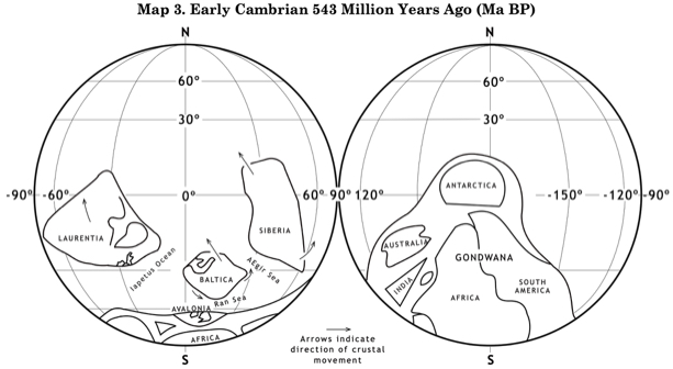
First look at the global Cambrian map on the left. Note the position of England and Wales on the nothern coast of Avalonia, bordering the Ran Sea, and Scotland on the southern shore of Laurentia. Then look at the detailed Cambrian map at the lower left to see the palaeogeograpy of the time. Each map is accompanied by an imaginative description (in italics) of what it would be like to visit that period of time, followed by a factual description of the geology of the period. The following is the relevant text extracted from the book for the Cambrian.
Setting the Scene
Imagine what it would have been like to stand on the shore of the Ran Sea looking northwards towards Baltica and the grey, cloud-filled horizon. It's winter near the south pole and the temperature is down below freezing, while a bitter wind from the south blows hard into your back. Waves, generated in a recent storm far out to sea, fight onto the shore against the wind and break whilst their white crests are blown away to the north. The strong, turbulent, grey currents sweep across from the south-west and on to the open Ran Sea to the north-east.
You stand on the land and listen to the roar of the wind and the crashing of the waves. There is no enormous ice cover, like the one we have today in the Antarctic, but the land is nonetheless covered in some drifting winter snow. The main thing that you would have noticed is that at this early stage in the march of evolution there is no life on land at all; no vegetation, no animals, and no birds in the air. None of our familiar seals, penguins, squawking shearwaters or majestic albatrosses.
You wouldn't be able to actually smell the sea spray - you would be wearing an oxygen mask, because at this time there was much less oxygen than today. Equally problematic for you, the carbon dioxide level in the atmosphere was five times today's level, increasing over the duration of the Cambrian to about fifteen times today's concentration. As you turn to glance south to look across the extensive plains of Pretannia, you reflect that since carbon dioxide is a 'greenhouse gas', this is the likely reason why the south pole was not covered in the thick ice it is today. The reason that there was so little oxygen in the atmosphere is because plants had not yet evolved on land. It was green plants, giving off oxygen as a by-product of their metabolism, that turned our atmosphere into an oxygen-rich gas mix.
The story out in the sea would be a totally different matter. In the Ran Sea, the water would be crystal clear; mainly because the rivers are frozen solid, and no sediments are being washed out into the seas that are teeming with life - particularly the newly evolved invertebrates, such as trilobites, looking like large woodlice, and bivalve brachiopods characterised by their two different sized shells. Perhaps you bend down and pick up some of the sea shells thrown up onto the foreshore by the waves, and you notice that the two shells of the brachiopod are quite different in size and shape.
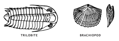
That makes them quite unlike the ones we collect today, where both shells are the same size. That's because brachiopods became more or less extinct about 24 million years ago. What we collect on the sea shore today are lamellibranchs, which didn't evolve until after the Cambrian.
It's evolution, and Nature's way - our modern lamellibranchs filled the niche left behind by the extinnct brachiopods.
The water temperature would be around 4 derees Celsius, perhaps a little less saline than today, but sufficiently saturated with calcium carbonate to provide the raw material for the newly-evolved creatures to precipitate on their outer surfaces to form their shells. Beneath the surface, the cold water would be rich with nutrients, feeding the burgeoning populations of bivalve brachiopods, trilobites, corals, and the snail-like gastropods that evolved during the late Cambrian.
Things would change with the spring thaw though. Snow melt run-off in the spring would be dramatic. With no ground vegetation, erosion would be violent and unrestrained, leading to rapid sedimentation in the sea. The near-shore waters of the Ran Sea would now be heavy with suspended sediments from Avalonia in the south and Baltica a few hundred kilometres further north. Many of the sea floor dwelling animals would be overcome and buried under the spring sediments - ideal fossilisation conditions - for us to find five hundred million years later in what we now call the Welsh Basin.
When the summer came, the wind blowing offshore would carry large quantities of dust in the dry periods. There was no vegetation to resist the wind and rain, or to hold the soil together. And of course soil wouldn't be the dark organic material we know today, because there would be no worms, fungi, or bacteria on land to help to create that wonderful organic material. So, summer rainfall erosion would be severe - for the same reasons.
All in all, the Cambrian land of Pretannia would be a strange and alien place. Far removed from our currently-temperate islands of Great Britain and Ireland.
You decide that you have had enough cold weather, and you return gratefully to today, to rest in front of a warm fire.
Historical Geology in Maps
Peter Roberts
Palaeogeography
Paleogeography
Ancient climate
Plate tectonics
PLATE TECTONICS
This book contains twelve sequential maps of the world's tectonic plate movements for the last 750 million years. plus a palaeo- geographical map of the British Isles for every major geological period.
But, if you are not wanting the British Isles or Irish information particularly, you can buy the book "Tectonic Plates" by Dr Roberts. Go to Science>Geology>Tectonic Plates
The Geology
The main feature that characterised the Cambrian period all over the world was the evolution of advanced forms of marine life. This is made apparent in sedimentary rocks laid down in the region now occupied by the British Isles. At the same time there was a general rise in relative sea level that took place throughout most of the Cambrian period, only steadying during the final few million years.
The rise in sea level led to the steady erosion and submergence of large areas of what had been the old Pre-Cambrian land surface, unconformably covering over the folded Pre-Cambrian rocks with shallow-water marine sediments. In Scotland, for example, the basal Laurentian Cambrian marine beds can be seen to unconformably overlie the Pre-Cambrian Torridonian Sandstones.
The area now occupied by England and southern Ireland was part of a small crustal plate called Avalonia, being situated close to the then south pole - as can be seen on Plate Migration Map 3.
The main, more-detailed, Cambrian map of the British Isles and Ireland has a diagonal SW-NE dividing line representing many thousands of kilometres of Iapetus Ocean between Avalonia to the south-east and Laurentia to the north-west.
Scotland and north-western Ireland were a coastal part of the completely separate Laurentian plate which was rapidly migrating northwards. To the south-west is marked the Avalonian Plate, with the shallow sourthern margin of the Ran Sea covering what is now England and Southern Ireland, depositing grits, sandstones and silts.
At this time the distance between Avalonia and Laurentia was several thousand kilometres, as shown on Plate Migration Map 3. The plate more immediately adjacent to Avalonia was Baltica, which was separated from Avalonia by the smaller Ran Sea. The Laurentian Plate was already moving away during the Cambrian and would continue to do so during the Ordovician. It would not move back to collide with Avalonia, and fix Scotland onto England and southern Ireland until the end of the Silurian. Thus the Scottish Cambrian beds were deposited thousands of kilometres away from the Welsh and English ones, and display characteristics more associated with the present Greenland and North American continent than Wales or England.
A low-lying Avalonian land area locally called Pretannia is shown on the map, bordered to the north-west by two unstable, geosynclinal sinking regions where silts, sands, and grits were deposited to a great thickness. Trilobites and brachiopods were amongst the rich fauna found in the rocks of the period. The Pretannia coastline follows the general structural trends of the Cambrian in Avalonia.
The steadily sinking sea floor in the Welsh Basin often resulted in sediment instability, with characteristic turbidite and greywacke formation. As well as the grits and sands illustrated on the detailed map, which show evidence of the north-easterly flowing currents, there are sedimentaries displaying graded bedding; the lower portion of each bed containing increasingly coarse particles towards its base. Sediments disturbed by storms or seismic events flowed towards the basin centre in the form of turbidity currents; upon reachig the deeper, flatter sea floor, they spread out and settled, with the coarser fraction dropping out first, followed later by the settling out of increasingly finer particles.
Although normally common in geosynclinal environments, volcanic rocks are rare in the British and Irish Cambrian sequences. Deposits across the Iapetus Ocean in the Laurentian coastal region of what is now Scotland, were primarily quatrzitic sands, sequentially followed by dolomitic limestones.
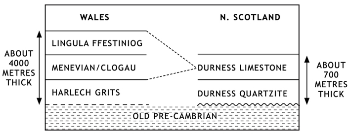
South of Scotland, and back across the Iapetus Ocean, in Avalonia, owing to the great variety of Cambrian strata, it is generally accepted that the Cambrian should be simply divided into Upper, Middle, and Lower, as shown in the upper diagram below:
The lower diagram below shows the approximate relationship between the Welsh sequence of rocks and the north Scotland Cambrian rocks of Laurentia. The difference at that time was caused by the still huge gap across the Iapetus Ocean. Off the Laurentian coast, predominantly siliceous marine sediments were followed by calcium carbonate limestones. These comprise the rocks now called the Durness Quartzite and the overlying grey-coloured, well-bedded Durness Limestone.
Historical Geology in Maps
Peter Roberts
THEY LIKED IT—SEE IF YOU LIKE IT BEFORE YOU BUY
THESE ARE A FEW EXTRACTS FROM THE BOOK
By clicking "Add to Cart", you confirm that you have read and agreed to our terms of business and payment procedures.
An unsolicited review by a retired geologist.
"Great book! I've been waiting for something like this for years. To be able to look at an outcrop of rock together with this book and be able to understand its provenance in terms of palaeogeography, palaeo position relating to the equator and degree of, or lack of metamorphism relating to tectonic history. Everything really, and all in a little book that is no bulkier than an OS map and accessible enough to get to the information that you need. I was a geologist in my twenties in the 1970/80s. Things have moved on since then but this book pulls it all together for me."
An unsolicited testimonial by an amateur geologist.
"I can't say enough good things about your book. As someone who always had an interest in geology I find this an indispensable guide to local and global geology."
An unsolicited comment by a retired geology teacher.
I have just bought and read your 'Historical Geology in Maps'. What a clear, concise, simply superb book. I am a retired geology teacher and this is by far the best and clearest book on the subject. I love it!
An unsolicited comment by an amateur geologist.
There is no better introduction to plate tectonics and the paleogeography of Britain. Superb.